
Preview




Description
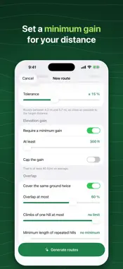
TrailGen finds the route that packs the most elevation gain into your target distance. Training for a mountain trail race while living in a flat area is a constant struggle. Standard route planners calculate paths from point A to point B. None of them actively analyze local terrain to maximize vertical gain. TrailGen explores trails around your starting location and keeps the loops that climb the most. • Find the best loop for your starting point and desired distance. • Repeat a hill by setting your target number of climbs and allowed trail overlap. • Draw custom routes on the map with instant distance and gain updates. • Select terrain preferences to allow, avoid, or block trails, dirt roads, and paved roads. • Block specific trail segments or draw entire avoid zones. • Relocate your start point within a set radius to find steeper options nearby. • Analyze elevation profiles color-coded by grade, surface breakdown, overlap, and trace silhouette. • Navigate offline on Apple Watch, with the workout written to Apple Health. • Plan race nutrition with timed carbohydrate and fluid reminders along your route. • Export GPX files, share route images or videos, or import existing GPX tracks. • Run offline by downloading map sectors to your phone. TrailGen runs on a proprietary algorithm built specifically for finding elevation gain. Elevation calculations draw from the highest-resolution public datasets available in each country. The app is free to download. Map viewing, manual routing, GPX imports, elevation profiles, and two daily route searches are free. A single lifetime purchase unlocks unlimited searches, GPX exports, the Apple Watch app, and nutrition planning. No subscription, no ads, no account, no tracking. Elevation data comes from USGS 3DEP (10m) in the United States, IGN RGE ALTI in France, Natural Resources Canada, and AWS Open Data Terrain Tiles elsewhere. Trail geometry comes from OpenStreetMap. Elevation models carry noise, which can overstate gain on flat ground. Trails on OpenStreetMap can be closed, modified, or private: check your route before leaving and trust real-world conditions on site. Map background: Mapbox. Support: https://github.com/a-leblond/privacy-policy/blob/main/trailgen-help.md Privacy Policy: https://www.trailgen.app/en/privacy Terms of Use: https://www.apple.com/legal/internet-services/itunes/dev/stdeula/
What's New
Version 1.3.1 2026-10-26
TrailGen is now optimized for iPhone Duo. When you unfold it, your routes move to a panel on the left and the map fills the rest of the screen. Open it halfway ... Technical Analysis
Package Overview Basic metadata
Bundle ID
com.aleblond.Trailgen Current Version 1.3.1
Minimum iOS 26.0
Package Size App Store Size
Package Metadata 0 / 0 version records
Detailed binary, privacy manifest, framework, and Info.plist results have not been indexed for this package yet. The verified App Store and archive metadata above remains available.
Price History (USA store)
2 recorded price change points. These are historical observations, not a guarantee of the current price.
| Recorded at | Price | Currency |
|---|---|---|
| 9.99 | USD | |
| 0.0 | USD |
Developer Information
Known Version Records
0 version records with stored package metadata
Stored metadata does not guarantee a package is currently available to download.
| Details | Version / IDs | Version date | Action |
|---|