
Preview




Description
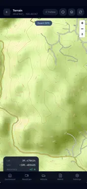
HotZone AI is built for firefighters, hazmat responders, and emergency personnel who need faster access to critical scene information during hazardous incidents. Whether responding to a hazmat release, wildland fire, vehicle emergency, or complex field incident, HotZone AI helps teams improve situational awareness with AI-assisted size-up, terrain intelligence, weather insights, incident tracking, and structured reporting tools. Designed for use in the field, HotZone AI helps responders identify hazards, document key details, and access operationally relevant context that supports safer, faster, and more confident decisions. Features include: AI-assisted hazmat and wildland scene size-up Terrain and topographic mapping with real-time GPS GIS overlays including wildfire perimeters, roads, trails, and evacuation zones Fire weather intelligence with wind, humidity, temperature, alerts, and trend indicators VIN lookup and vehicle rescue guidance, including EV and high-voltage identification Incident history, status tracking, and timeline visibility NERIS-aligned structured incident reporting CAD / dispatch import with configurable field mapping Admin tools for department identifiers and agency configuration ERG and NIOSH reference support A clean, field-ready interface designed for high-pressure environments HotZone AI is designed to complement department training, SOPs, and command structure by organizing critical information quickly and clearly when it matters most. Important Notice HotZone AI is a decision-support tool and is not a substitute for official training, standard operating procedures, incident command, or professional judgment. Always follow agency policy and established responder safety practices.
What's New
Version 1.0.1 2026-03-22
This update adds major new field capabilities for terrain awareness, fire weather, rescue intelligence, and incident reporting. New Terrain Map with topo detai...This update adds major new field capabilities for terrain awareness, fire weather, rescue intelligence, and incident reporting. New Terrain Map with topo detail, contour lines, GPS tracking, and Follow Me mode New GIS overlays for wildfire perimeters, incidents, roads, trails, hydrants, parcels, and evacuation zones New Fire Weather Intelligence with live NWS wind, humidity, temperature, alerts, and trends New Vehicle Rescue Guide with VIN lookup and EV/high-voltage identification New NERIS-aligned incident reporting and export-ready structured data New CAD/dispatch import tools with configurable field mapping New Wildland Camera Network with favorites, filtering, and direct stream support Technical Analysis
Package Overview Basic metadata
Bundle ID
com.base69914339c425ba05c8774669.app Current Version 1.0.1
Minimum iOS 15.1
Package Size App Store Size
Package Metadata 0 / 2 version records
Detailed binary, privacy manifest, framework, and Info.plist results have not been indexed for this package yet. The verified App Store and archive metadata above remains available.
Known Version Records
0 version records with stored package metadata • 2 known version records
Stored metadata does not guarantee a package is currently available to download.
| Details | Version / IDs | Version date | Action |
|---|---|---|---|
| Not archived | App Store ID: 883161201 | Unknown | Request Version |
| Not archived | App Store ID: 882801782 | Unknown | Request Version |