Preview




Description
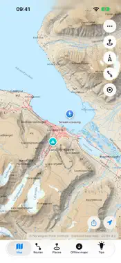
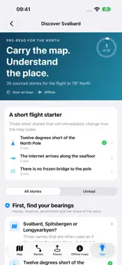
Svalbard in your pocket—before, during and after the journey. Download maps before mobile coverage disappears. Plan a route, follow your position, record a private track, save places and discover what makes life at 78° North possible. MAPS FOR THE FIELD • Download selected topographic areas for offline use. • Preview saved maps before leaving coverage. • See your current GPS position and heading. • Switch between topographic, satellite, orthophoto and nautical views when online. • Add optional depth soundings to the nautical chart for planning. ROUTES, TRACKS AND GPX • Explore eight trek recordings as references in one map-first view. • Build multi-point route plans with distance and terrain elevation profiles where coverage is available. • Record your own breadcrumb track—even while your iPhone is locked or you use another app. • Import GPX routes, tracks and waypoints with a clear preview before anything is saved. • Export planned routes, recorded tracks and saved places as GPX. DISCOVER SVALBARD—OFFLINE Read 35 approachable stories across five chapters, from the hidden systems behind Longyearbyen to sea ice and the North Pole. Search the collection, track what you have read and open relevant locations on the map. Every story is stored in the app and includes sources and a fact-check date; external source links require internet access. YOUR PLACES. YOUR DATA. Save camps, viewpoints and other personal places with categories, notes and coordinates. Share one place or a selected group as GPX when you choose. LIVE CONDITIONS AND OFFICIAL LAYERS • Check MET Norway forecasts, nearby station observations and warnings, Kartverket tides, the Svalbard sea-ice chart and NVE avalanche bulletins for a selected location. • Keep the latest downloaded conditions available with clear source, age and stale/offline labels. • Add weather, tide and field-condition widgets after opening Conditions in the app. • Consult official-data maps and sourced guidance for snowmobile access, protected areas, landing sites, cultural heritage and hunting zones. • Follow an active track recording from its Live Activity. No account. No advertising. No analytics. Your routes, tracks, places and downloaded maps stay in the app’s private storage on your iPhone unless you choose to export or share them. When you request Conditions for a location, the selected coordinate is sent directly to the named official data providers; the developer does not receive it. IMPORTANT Svalbard Map is a planning and navigation aid—not a safety or rescue system, turn-by-turn navigator, or official nautical chart. Suggested treks are reference recordings, not maintained routes or evidence that access or conditions are safe. Maps, tracks, terrain estimates and guidance may be inaccurate, incomplete or out of date. Confirm current conditions, restrictions and your route independently. Carry appropriate navigation, communication and safety equipment, follow the Governor of Svalbard’s current requirements, and never rely on a phone or map app for emergency response. Map data: © Norwegian Polar Institute—Svalbard base map, satellite imagery and orthophoto; satellite imagery includes Copernicus Sentinel data. Nautical chart and depth data: © Kartverket. Terrain elevation: © Norwegian Polar Institute. Attributions and licence links are available in the app.
What's New
Version 1.3 2026-10-12
New tools for exploring Svalbard, on and offline. • Conditions: weather forecasts, nearby station observations, warnings, tides, sea-ice charts and avalanche b...New tools for exploring Svalbard, on and offline. • Conditions: weather forecasts, nearby station observations, warnings, tides, sea-ice charts and avalanche bulletins from official sources, with update times and offline cache labels. • Weather, tide and field-condition widgets, plus a Live Activity for track recording. • Six languages: English, Norwegian Bokmål, Swedish, German, French and Simplified Chinese. • Official map layers and sourced guidance for snowmobile access, protected areas, landing sites, cultural heritage and hunting. • Improved language switching, large-text layouts, route calculations and protection of saved data. Free, with no account, ads or analytics. Technical Analysis
Package Overview Basic metadata
Bundle ID
com.adamzemancik.svalbardmap Current Version 1.3
Minimum iOS 17.0
Package Size App Store Size
Package Metadata 0 / 0 version records
Detailed binary, privacy manifest, framework, and Info.plist results have not been indexed for this package yet. The verified App Store and archive metadata above remains available.
Known Version Records
0 version records with stored package metadata
Stored metadata does not guarantee a package is currently available to download.
| Details | Version / IDs | Version date | Action |
|---|